Digital Twins for Cities
| Language: | Deutsch |
| Location: | München, Remote |
| Duration: | 6 days in 3 weeks |
| Start: | February/March 2024 |
| Cost: | 3.750 € |
The Digital Twins of a city are a virtual image of buildings, streets and entire urban districts and their environment. A multitude of data from a wide variety of sources complements the Digital Twins to form a valuable planning instrument that can provide up-to-date information and forecasts at any time.
A great advantage is the simple and clearly understandable visualisation of complex calculation results in the models. In this way, they provide reliable support for citizen participation and decisions on improving mobility flows, meeting climate targets, developing new construction areas or implementing security concepts.
The group of participants is limited to a maximum of 20 people and is made up of executives and project managers from the fields of urban planning, engineering and architecture offices, municipalities, surveying and geodesy as well as business development Smart City.
Within our certificate course we discuss questions such as:
- What are Digital Twins for Cities?
- What standards are there?
- What data are included?
- How can the Digital Twins for Cities be used?
- What are the components of Digital Twins for Cities?
Quick Info
Benfits
-
Innovative Urban Modeling
Experience digital transformation in urban planning with state-of-the-art Digital Twin technologies for a more sustainable future.
-
Practical Expertise
Benefit from practical insights and lead projects with expert knowledge in Smart City development and civil engineering.
-
Exclusive Network
Build a strong professional network and engage with leaders and experts in the field of digital urban planning.
Program Overview
You can find all the important information about the certificate program here. Below you can find out the objectives of the program, the exact details of the process, what you will learn and which lecturers will teach you the content.
Aims of the certificate course
Our in-service training program shows you how to combine interdisciplinary solutions into a virtual city model – the digital twin. The digital twin serves as a basis for decisions regarding sustainability, safety and quality of life in the built environment.
We present innovative methods from the fields of civil engineering, geoinformation and urban planning. Evaluate the possibilities of digital networking and emerging new business models. Get to know cross-topic and cross-scale digital analysis methods. Develop individual solution strategies for complex urban issues. Build up your network for future activities.
Details
| Program: | Digital City – Modeling, Analyzing & Deciding |
| Graduation: | After successfully passing the final examination, you will receive a certificate from the Technical University of Munich. |
| Academic Responsibility: | Prof. Dr. rer. nat. Thomas H. Kolbe Prof. Dr.-Ing. Frank Petzold Prof. Dr.-Ing. André Borrmann |
| Target Audience: | Executives and project managers working in town planning and architecture Employees responsible for planning at communal institutions Experts within the fields of Smart City, measurement and geoinformation |
| Participation fee: | 3.750 Euro* |
| Language: | German |
| Discounts: | 10% discount for TUM Alumni and members or employees of our strategic cooperation partners (see below). |
| Dates: | Module 1, online: February 19th, 20th, 23rd, and March 4th, 2024 (09:00 to 15:30) Module 2, on-site in Munich: March 7th and 8th, 2024 (09:00 to 17:30) |
| Study location: | Online and on Campus (Munich) |
| Format & Timing: | 2 modules in a total of 6 days (part-time) |
| Access Requirements: | Participants should have relevant work experience of at least 2 years and ideally a higher education degree or a degree from a university of applied sciences. |
* Based on our experience, the German tax benefits help many of our participants to self-finance their education as these can be worth of up to 50% of tuition fees and program related travel costs. Please, consult your personal tax advisor for more details. For participants of our programs residing outside Germany this might be applicable, please check the situation with the local tax authorities in your country of residence.
Lecturers
| Big Picture | |
| Prof. Dr. rer. nat. Thomas H. Kolbe, Chair of Geoinformatics, TUM | Markus Mohl, City of Munich, Municipal Department, Geodata Service |
| Jarmo Suomisto, HELSINKI 3D+, City of Helsinki | Klaus Illigmann, Head of Department for Urban Planning and Building Regulations, Munich |
| Basics | |
| Prof. André Borrmann, Chair of Computational Modeling and Simulation, TUM | Prof. Frank Petzold, Chair of Architectural Informatics, TUM |
| Modelling | |
| Dipl.-Ing. Markus Hochmuth, BIM und Digital Engineering Solutions, OBERMEYER Planen + Beraten GmbH | Ludwig Hoegner, Photogrammetry and Remote Sensing, TUM |
| Jürgen Utz, DGNB Academy | |
| Usage | |
| Dr. Stefan Trometer, Virtual City Systems | Dipl.-Ing. Martin Margreiter, Chair of Traffic Engineering and Control, TUM School of Engineering and Design |
| Preview | |
| Christian Veldhuis, Municipality of Rotterdam | Michael Mühlhaus, urbanistic |
| Dr. Gerhard Schubert, Chair of Architectural Informatics, TUM |
Structure
Digital city modeling
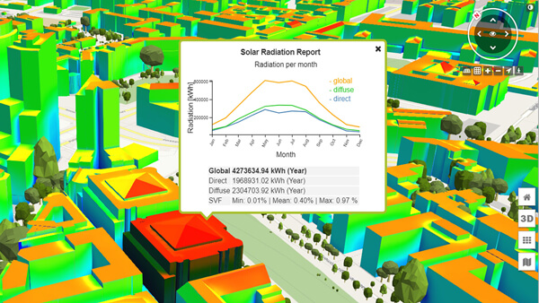
Modern solar potential analyses allow the evaluation of façade surfaces and the consideration of shading effects from buildings, vegetation and terrain. With the solution developed jointly by TUM and Virtual City Systems GmbH, you can balance the potential on a monthly basis and have it displayed and evaluated for each individual building.
Digital planning and construction (BIM)
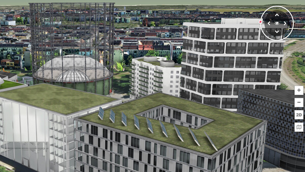
We will show you how the new worlds of Building Information Modeling (IFC) and Urban Information Modeling (CityGML) are growing together using the visualization of BIM models in the context of the semantic 3D city model of Berlin by Virtual City Systems GmbH.
Application (mobility, environment and housing)
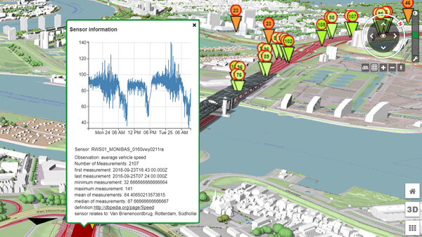
Web-based 3D city models, as shown here using the example of Rotterdam, can be expanded into data hubs and can be linked with real-time sensor systems for traffic events.
Testimonials
Partners
The program was developed in cooperation with the Leonhard Obermeyer Center of TUM, CADFEM, Virtual City Systems GmbH, DGNB Akademie and Bayerische Architektenkammer.

Your contact
Franziska Sennebogen
Program Manager
Phone: +49 89 289 26761
E-Mail: digital.twins@lll.tum.de
